|
Flinders Ranges Holiday Destinations & Towns
South Australia
ARKAROOLA
Arkaroola
is a 61,000 hectare
privately-owned wildlife
sanctuary in the rugged
northern flinders Ranges
just to the east of
the Gammon Ranges National
Park. It shares features
seen in that park -
including spectacular
arid zone mountain terrain,
picturesque gorges,
water holes and wildlife
unique to the area.
Arkaroola Village,
a motel, caravan and
camping complex, is
the focus for the
sanctuary, purchased
by the current owners
in 1968. Until then,
the area was made
up of a series of
degraded pastoral
leases infested with
vermin; these were
eradicated, and today
Arkaroola is a fine
example of a privately-run
sanctuary. The scenic
waterholes of Nooldoonooldoona,
Bolla Bollana, Arkaroola,
Stubbs and Bararranna
are well worth a visit.
BELTANA
Beltana
is an old railway town
on the western fringe
of the Flinders Ranges.
Today, it is a historical
reserve off the main
Hawker-Leigh Creek road.
The detour is worth
it. Many of the town's
buildings are being
or have been restored,
making Beltana a time-capsule
of the I9th century.
These include the
original Beltana Homestead
(1855), Police Station
(1881), Post Office
and Telegraph (1875),
Bush Hospital (1898)
and School (1882).
The "Smith of
Dunesk Mission Church"
was opened in 1895
and was the base from
which Rev. John Flynn
pioneered the Royal
Flying Doctor Service
and the Australian
Inland Mission.
Beltana was also the
base for pastoralists
Thomas Elder and Robert
Ban-Smith, co-founders
of Elders. In the
early days it was
a camel breeding station.
When the railway was
replaced in 1956,
Beltana slowly fell
into disuse. Note:
the buildings in Beltana
are privately-owned
and are generally
not open to the public.
BLINMAN
At
the northern end of
the Flinders Ranges
National Park, Blinman
was a thriving copper
town between 1862 and
1830. Robert Blinman's
discovery of the metal
in 1859 built up high
hopes for the future
of the town that bears
his name.
Some old mine machinery,
early buildings and
an historic cemetery
remain as a reminder
of the town's history.
BOOLEROO
CENTRE
Population:
333
Booleroo Centre
is the centre of a thriving
wheat and pastoral district
in the southern Flinders
Ranges.
HAWKER
Population:
302
The locals call this
the hub of the Flinders,
with some justification
- it is the junction
of roads from Port Augusta,
Orroroo, Marree and
Wilpena Pound. It was
once a thriving railway
town, a typical outback
town, but when the line
was re-located. Hawker's
pace slowed somewhat.
It is, however, an important
tourist town servicing
the traffic into the
central and northern
Flinders Ranges and
has all necessary facilities.
LEIGH
CREEK
Population:
1,635
Leigh Creek's enormous
brown deposits of brown
coal were first mined
in 1943. The Electricity
Trust of South Australia
operates the mine and
currently extracts 2.3
million tonnes every
year. Once reduced to
small pieces, the coal
is loaded onto special
trains which take it
to a power generating
plant at Port Augusta
at the head of Spencer's
Gulf, a distance of
two hundred and fifty
kilometres.
Book a tour of the
coalfields, visiting
the mine site viewing
area and Aroona Dam.
LYNDHURST
These
days it's famous for
being the beginning
of the Strzelecki Track,
but last century Lyndhurst
was an important outback
railhead. The large
area of ochre cliffs
ranging from reds, browns,
yellows and whites on
the outskirts of the
town on the Marree road
are a colourful attraction.
MELROSE
Melrose
is the oldest town in
the finders Ranges and
has been used as a movie
set on several occasions.
The discovery of copper
gave birth to it while
today it services a
large and prosperous
grain growing industry.
It is also one of the
most beautiful towns
of the Flinders Ranges,
nestled at the foot
of Mount Remarkable
and next to the Mount
Remarkable National
Park. Climb to the War
Memorial for a panoramic
view over the Willochra
Plain, or to Lookout
Hill near the water
tanks. Cathedral Rock
is a spectacular formation
along the edge of Mount
Remarkable Creek west
of the town. Day trips
in and around the area
lead to some of many
scenic areas of the
finders Ranges via the
National Park and gorges.
PETERBOROUGH
Population:
2,239
Peterborough is a historic
railway town and an
important stop on the
way to the Flinders
Ranges, It is one of
only two railway junction
towns in the world where
three railway line gauges
meet.
PORT
AUGUSTA
Refer
to "South Australian
Outback Towns"
PORT
GERMEIN
Population:
218
This once-busy wheat
shipping port had the
longest wooden jetty
in the southern hemisphere,
but storms in 1881 and
several times this century
damaged it. The jetty
has since been repaired
and anglers are now
frequent users.
QUORN
Population:
1,073
Quorn, an old railway
town was once an important
junction for east- west
and north-south rail
traffic in the days
of narrow gauge rail
lines. The construction
of a new standard gauge
railway line from Port
Augusta to Marree in
1956 bypassed Quorn
and lessened its importance,
but the re- opening
of part of the Pichi
Richi line has introduced
tourism as a new industry.
Quorn is nestled in
the beautiful finders
Ranges and has lost
none of its enchanting
old world character.
WILMINGTON
Population:
233
Wilmington's early settlers
called it Beautiful
Valley, and the name
says it all. Located
at the top of Horrocks
Pass, close to stunning
Alligator Gorge, the
town shares its main
attractions with nearby
Melrose and Mount Remarkable
National Park.
WIRRABARA
Population:273
State-owned pine forests
surround Wirrabara,
first settled in 1844.
There is a timber mill
near the town, and a
steam engine which once
used to cut timber can
be seen in the main
street.
WILPENA
Wilpena
Pound is arguably the
Flinders Ranges' single
greatest natural asset,
certainly its best-known.
The Pound's upturned
hand and gnarled fingers
are a part of the Flinders
Ranges National Park
and offer the visitor
magnificent scenery,
bushwalking trails aplenty,
Aboriginal and white
history, abundant wildlife
and dense native vegetation.
There are no cars in
the Pound and entry
is through a narrow
gorge above Sliding
Rock while walking trails
crisscross its floor,
slopes and ridge-tops.
Out from Wilpena,
there are numerous
scenic drives to other
natural features in
the national park
- including Sacred
Canyon with its Aboriginal
carvings, Stokes Hill
Lookout, Aroona Valley,
Brachina Gorge, Bunyerxo
Valley, Wilkwillana
Gorge and the Aboriginal
carvings at Arkaroo
Rock.
AUBURN
Population
325
Auburn is a pretty town
at the southern gateway
to the Clare Valley.
It dates from the 1840s,
when it serviced the
bullock wagons travelling
between Burra's rich
copper mines and the
coast. A walk along its back
streets is like taking
a step back in time
- many of its original
buildings remain,
especially St Vincent
Street. Walking tour
guides are available
from the National
Trust or Aubum Stores.
Famous colonial bard
CJ Dennis, author
of 'Sentimental Bloke'
was born and spent
his early years here. BALAKLAVA
Population:
1,365
Balaklava, named after
the battle in the Crimean
War, was established
by Adelaide grain merchant
Charles Fisher in 1870
when he built large
grain stores as an inducement
to farmers to open up
the land. The town services
a rich pastoral area
today.
BURRA
Population:
2,225
Copper was discovered
around Burra in 1845,
and soon a bustling
town had grown around
the site. The Burra,
as it was known, consisted
of a series of small
townships based around
the nationalities of
the miners who lived
there. Kooringa and
Redruth were Cornish,
Aberdeen- Scottish,
Llywchwr- Welsh and
Hampton- English. Although
the mines were spent
in little more than
thirty years, the character
of Burra remains intact
thanks to a caring community.
While the town economy
is today based on the
pastoral industry especially
merino sheep farming,
the copper heritage
is evident everywhere.
Several museums interpret
the old mines site,
and numerous historic
residential and public
buildings have been
restored and put to
contemporary use.
Burra's Passport system
is an inviting and
novel way to see the
town's many attractions
- simply collect your
key from the Burra
Tourist Office, and
head off at your own
pace on an eleven
kilometre tour of
heritage buildings,
museums, mine shafts
and lookouts .
CLARE
Population:
2,591
In the beautiful
northern Mt Lofty Ranges,
Clare nestles among
wooded hills and orderly
vineyards. Its earliest
settlers were Irish,
and it's one of the
few South Australian
districts where an Irish
influence can be detected
in the lifestyle and
culture. Clare is the centre
of a prosperous pastoral
community and an important
wine industry. The
Clare Valley's slopes
and valley floors
provide a cooler climate
for later maturation
than in the Barossa
Valley, and the district's
wines have a reputation
for quality and character.
It's one of the most
picturesque wine producing
areas in Australia. CRYSTAL
BROOK
Population:
2,100
Indomitable explorer
Edward John Eyre named
the creek which runs
into the River Broughton
the 'Chrystal Brook'-
the spelling is his.
The name stuck and a
town grew near the spot
where his party camped
in 1839. Before the
town grew, however the
site was swallowed up
by the huge pastoral
landholding belonging
to William Younghusband
and Peter Ferguson.
Crystal Brook today
is a nature lover's
mecca. The Heysen Trail
runs past the town and
Bowman Park.
JAMESTOWN
Population:
1,300
When expansion on the
land gathered pace in
South Australia in the
mid to late I9th century,
scores of ambitious
farmers followed the
trail northwards. The
area around Jamestown
was opened up in the
1870s, and it soon became
an important grain district.
It remains so today.
There are also extensive
forests nearby at Bundaleer.
KAPUNDA
Population:
1,622
Kapunda was the site
of Australia's first
viable copper mine.
Its economic significance
to the young colony
was enormous. In near
bankruptcy due to speculation,
the discovery of copper
gave South Australia
the leg up it needed.
The mines operated between
1844 and 1912, and produced
14,000 tonnes of copper
metal. Kapunda's streetscape
reflects this prosperous
past, with numerous
historic buildings,
museums and churches.
Many wear the characteristic
old 'Kapunda Lace' on
their verandahs, intricate
decorative ironwork
designed and manufactured
in the town last century.
The Cattle King, Sir
Sidney Kidman also
lived in Kapunda for
many years. His home
Eringa is now part
of the high school.
A one-and-a-half kilometre
walking trail takes
visitors past the
old mine site and
its surroundings.
A booklet of the town's
significant buildings
is also available.
PORT
PIRIE
Population:
15,114
This is the region's
largest centre. It has
always played a crucial
role in the state's
economy. Broken Hill
silver, lead and zinc
deposits have provided
significant earnings
for the city for generations,
while grain from its
hinterland has been
shipped from the port
for over a century.
Contemporary Port
Pirie has a rich cultural
life, and its location
near the Flinders
Ranges makes it a
good base for visitors
intending to explore
further afield.
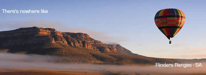
Photo courtesy SATC
|
|
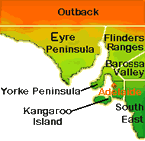
South Australian Region
Map |
|
Yorke Peninsula Information |
|
|