Wilsons Promontory - Gippsland Victoria
Wilsons Promontory National Park is a national park in the Gippsland region of Victoria, 157 km southeast of Melbourne, covers 50,512 hectares including offshore islands and the Light Station.
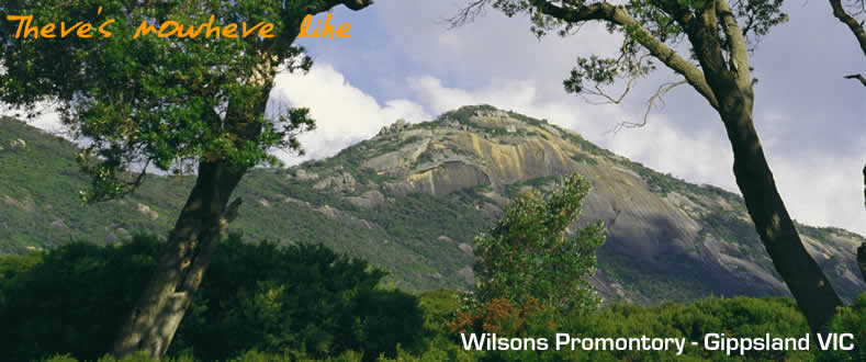
Wilsons Promontory, locally known as The Prom, is mainland Australia's southern most National Park, and is well loved across the state for its wild and untouched scenery, massive lichen covered boulders strewn at the edges of long sandy beaches, and tree covered mountains that sweep down into calm rivers.
It is a landscape made all the more special by the fact that it is bordered on all sides by sea. It has limited road access, but this just makes the opportunities for walking all the more magnificent.
The park features dozens of well marked walking tracks, that lead to isolated beaches, clear water and magnificent camping spots, some are easy strolls, such as the 5 klm Lilly Pilly Gully nature walk, taking in the region’s native flora and fauna, and the 6 klm Pillar Point walk, which boasts views over Tidal River.
Wilsons Promontory - which juts out into Bass Strait - constitutes the southernmost point of the Australian mainland. It was described by explorer George Bass as the "cornerstone of this continent called "New Holland" after he saw the Prom in the first days of 1798.
Bass named the area Furneaux's Land but it was later renamed in honour of a prominent London businessman, Thomas Wilson. It is believed Wilsons Promontory was once part of a "land bridge" connecting the mainland with Tasmania. In another age the Prom is thought to have been an island. The gradual build up of a 20 kilometre stretch of sand dunes, known as the Yanakie Isthmus, is said to have reconnected the Prom with the mainland.
The Aborigines who once lived here were members of the Boon-Oor-Rong tribe and their middens are still evident on the western side of the promontory. Long before Bass's official visit, the area was frequented by sealers and whalers. Whale bones can still be seen in the waters of Sealers and Refuge Coves on the eastern side.
In many respects it is still much the same as it was at the time of Bass's first visit. It is comprised of imposing granite mountains, sweeping plains, thick forests and some of the finest beaches in the country. These range from sheltered little coves to long surf beaches.
The Prom is the ideal place for bushwalking and a full appreciation of the magnificent array of native wildlife Australia has to offer. The friendliest are the parrots which flock around anyone offering food at Tidal River.
Tidal River is the "capital" of the Prom. It is made up of an information centre, museum, caravan and camping grounds with some cabins. Here you will find a cairn which acknowledges the use of the Prom as a commando training camp during World War II.
(all photo's courtesy of Tourism VIC)